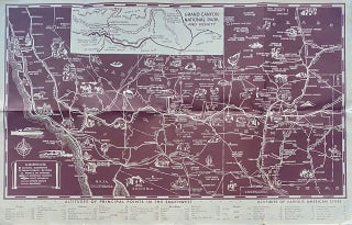
Illustrated Map of the Great Southwest. Including Points of interest in New Mexico and Arizona
[Kansas City, MO]: Fred Harvey, 1958. Map [35.5 cm x 56 cm] / [14" x 22"] printed in brown ink. Folds as issued. Nice condition. The reverse contains two panels of 'Indian Signs and Symbols' and a panel each for: 'Navajo Motifs: From Silverwork and Weavings' - Pueblo Motifs: From..... More